Tag Archives: Geology

AGU 2017, Day 3

What a day! I fortuitously came across quite a few people I know from either my undergraduate institution or my PhD work, and managed to catch up with some of them. I explored about a third of the exhibits in the exhibit hall, and learned about cool new instrumentation, including the Raspberry Shake.

In the afternoon, I went to a volcanology session about flood basalts and large igneous provinces, and it was riveting. Loyc Vanderkluysen is working on a new classification scheme for the Deccan Traps, which cover an area roughly the size of Texas and may have covered three times that area when they were first erupted. These lavas, found in modern-day India, have formation boundaries defined by their chemistry, but the choice of chemistry to use for classification and differentiation seems like it could be improved by modern data analysis techniques.

But the talk that really stood out was by Courtney Sprain, talking about dating the Deccan Traps. Papers published in 2015, one using U/Pb dating (Schoene et al.) and the other using Ar/Ar dating (Renne et al.), concluded that the Deccan Traps were erupted almost entirely between 67 Ma (Mega-annum, million years ago) and 65 Ma, right across the Cretaceous-Paleogene (K-Pg) boundary. However, the middle portion of the sequence was not dated sufficiently precisely to test whether the Chixulub impact caused increased volcanism in the Deccan Traps. In this new work, many additional samples have been analyzed with high-precision Ar/Ar using many multi-grain step-heating experiments. As a result, the data are now sufficient to test whether volcanism changed or increased at the same time as the impact. The K-Pg boundary occurs right at an important formation boundary, and Nd isotopes shift there (toward less crust-like, more mantle-like ratios) as well. Feeder dikes, which lower in the sequence were generally oriented in one direction, became randomly oriented above the chronological boundary.

All of which is to say, the new data are of a quality where it would be possible to falsify the hypothesis that the impact caused increased volcanism, but they do not falsify that hypothesis. Indeed, they are quite consistent with it. Wow!

Claims of impact-triggered flood basalts are rather radical, and need some solid data to back them up. The speakers in these sessions were clear to say that this isn’t by any means sufficient yet to declare the new paradigm accepted and move on. Still, this was a pretty big test of the hypothesis, and it came through unscathed.

In the morning, I will be presenting my poster on the retreat of Stephenson Glacier, Heard Island (poster C41B-1222). This conference has been keeping me very busy, and it looks like that will continue through the time I leave. I’m very excited about what I’ve been learning, the people I’ve been talking with, and the ideas that are coming together as a result of this conference. The long conference center (it’s nearly 1 km end-to-end) is keeping me in good shape, too!

Capitol Rock Close-Up

Close-up outcrop photograph of Capitol Rock, viewed from the north-northeast.  Image credit: Bill Mitchell (CC-BY).
Close-up outcrop photograph of Capitol Rock, viewed from the north-northeast. Image credit: Bill Mitchell (CC-BY).

Two years ago, I came tantalizingly close to Capitol Rock, an outcrop in southeastern Montana (45.572189, -104.087964) just a few miles over the border from Camp Crook, SD. Unfortunately, I did not have an opportunity at that time to explore the outcrop from any closer than about a quarter mile, but I did find the Ekalaka Quadrangle 30’x60′ (pdf) geologic map.

Recently, I was out in the area again, and this time made sure to have time to take some pictures and see some of what was to be seen. Let’s start with the quarter-mile view, which is roughly equivalent to what I saw last year.

Wide view of Capitol Rock from the east.  Image credit: Bill Mitchell (CC-BY).
Wide view of Capitol Rock from the east. Image credit: Bill Mitchell (CC-BY).

Capitol Rock has three major parts to it: an easily eroded base, a laminated sandstone middle, and a massive sandstone top. A handy turn-out from the forest service road leads right to the base of the outcrop.

The easily eroded base is made of fine, chalky, white sediment sediment, and it remains in horizontal orientation. In several places, this unit is at least superficially porous. Surprisingly, there are occasional chert clasts in the otherwise fine sediments—I’m not quite sure how those would have been deposited or formed here.

Basal unit of Capitol Rock.  Foot for scale.  Image credit: Bill Mitchell (CC-BY).
Basal unit of Capitol Rock. Foot for scale. Image credit: Bill Mitchell (CC-BY).
Cherty clast in the basal sediments at Capitol Rock.  Foot for scale.  Image credit: Bill Mitchell (CC-BY).
Chert clast embedded in the basal sediments at Capitol Rock. Foot for scale. Image credit: Bill Mitchell (CC-BY).

Above the basal unit is a somewhat more resistant, coarser-grained set of beds. These strata are finely bedded, and have a tendency toward spheroidal weathering. Occasionally interbedded with the spheroidal beds are 1–3 cm thick, well-cemented strata of a white or pink color [discoloration?].

Spheroidal weathering of finely-laminated strata.  Hand for scale.  Image credit: Bill Mitchell (CC-BY).
Spheroidal weathering of finely-laminated strata. Hand for scale. Image credit: Bill Mitchell (CC-BY).
Laminations in the unit displaying spheroidal weathering.  Hand for scale.  Image credit: Bill Mitchell (CC-BY).
Laminations in the unit displaying spheroidal weathering. Hand for scale. Image credit: Bill Mitchell (CC-BY).
Non-spheroidal bed 1–3 cm thick and slightly orange-pink in coloration, within the spheroidal beds at Capitol Rock.  Hand for scale.  Image credit: Bill Mitchell (CC-BY).
Non-spheroidal bed 1–3 cm thick and slightly orange-pink in coloration, within the spheroidal beds at Capitol Rock. Hand for scale. Image credit: Bill Mitchell (CC-BY).

The spheroidally-weathered unit also seems to have one or more channels within it.

Contact between spheroidally-weathered strata (above) and easily-weathered basal unit (below).  Possible channel cut at right.  Outcrop height in image is ~10 m.  Image credit: Bill Mitchell (CC-BY).
Contact between spheroidally-weathered strata (above) and easily-weathered basal unit (below). Possible channel cut at right. Outcrop height in image is ~10 m. Image credit: Bill Mitchell (CC-BY).
Contact between spheroidally-weathered strata (above) and easily-weathered basal unit (below).  Possible channel cut at right has been annotated.  Outcrop height in image is ~10 m.  Image credit: Bill Mitchell (CC-BY).
Contact between spheroidally-weathered strata (above) and easily-weathered basal unit (below). Possible channel cut at right has been annotated. Outcrop height in image is ~10 m. Image credit: Bill Mitchell (CC-BY).

The upper unit at Capitol Rock has more massive sandstone (see wide view above). I didn’t notice many channels in this unit, although I didn’t get very close. A butte just to the north of Capitol Rock provided a good photograph (below).

Massive unit of Capitol Rock, seen in the butte immediately to the north of Capitol Rock.  Cliff is ~30–40 m tall.  Image credit: Bill Mitchell (CC-BY).
Massive unit of Capitol Rock, seen in the butte immediately to the north of Capitol Rock. Cliff is ~30–40 m tall. Image credit: Bill Mitchell (CC-BY).

Although I have those observations, I don’t have much for interpretation of them. The depositional environment seems to be relatively low-energy (give or take the chert clasts), evidenced by the flat strata, fine grain sizes, and relatively few cross-beds. Changes in the rock types would suggest changes in the sediment sources or the depositional environment (or both). There may be post-deposition alteration effects as well, such as cementation of the spheroidally-weathering strata.

View SSE from the butte just north of Capitol Rock.  Truck for scale in pull-out near Capitol Rock.  Image credit: Bill Mitchell (CC-BY).
View SSE from the butte just north of Capitol Rock. Truck for scale in pull-out near Capitol Rock. Image credit: Bill Mitchell (CC-BY).

Capitol Rock is an interesting outcrop, and if you’re in the area, I’d recommend a stop. The rocks are interesting, there are US Forest Service campgrounds nearby, and the view is quite nice. These units can probably be correlated to the Slim Buttes in South Dakota (~45 miles east).

Nares Glacier to Mount Drygalski Panorama

Panorama from Nares Glacier (left) to Mt. Drygalski (right) from the Atlas Cove camp.  This view spans from ESE through SSW, and is roughly 85 megapixels at full size.  Image credit: Bill Mitchell (CC-BY, hosted on flickr).
Panorama from Nares Glacier (left) to Mt. Drygalski (right) from the Atlas Cove camp. This view spans from ESE through SSW, and is roughly 85 megapixels at full size (28 MB). Image credit: Bill Mitchell (CC-BY, hosted on flickr).

One year ago, I was on Heard Island. Over the course of the expedition I took more than 6000 photos. Although I took three images with the Gigapan (Big Ben, the Azorella Peninsula, and—my favorite—Windy City), I also took photos for stitching together manually using my own camera.

I have been slow in stitching these pictures together, but with the one-year anniversary of their production coming around, I decided it was time to finish one or two of them. This is the first, and I hope I’ll find time to finish more. Putting it together, I was amazed that this is still a relatively wide-angle compared to what I had available: 70 mm on a 70–200 mm lens. The detail came out well, as is evident at full-size. The glaciers, moraines, and hills are all more than a kilometer distant over the “nullarbor”, a broad, flat, volcanic-sand plain.

Toward the left half of the image are some penguins for scale. They look like king penguins, putting their height around 1 meter. I count at least 31 penguins in the entire image.

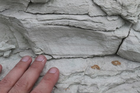
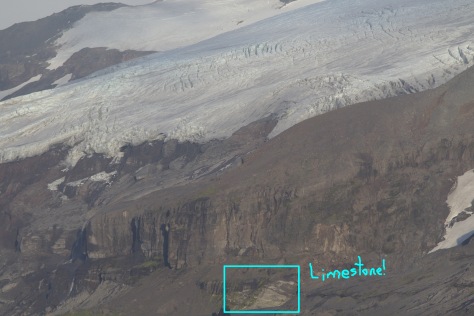
I think I spot some of the relatively rare basement limestones cropping out at the very left edge of the image, and their appearance is consistent with a dip of 25–35° to the south.[1] A closer view (200 mm focal length) shows them more clearly.

Location of limestone, with annotation.  Image credit: Bill Mitchell (CC-BY).
Location of limestone, with annotation. Image credit: Bill Mitchell (CC-BY).
Full-zoom on the limestone outcrop.  Bedding is clearly visible, dipping south.  Image credit: Bill Mitchell (CC-BY).
Full-zoom on the limestone outcrop. Bedding is clearly visible, dipping south. Image credit: Bill Mitchell (CC-BY).

[1] Quilty, P. G. & Wheller, G. 2000; Heard Island and The McDonald Islands: a Window into the Kerguelen Plateau. Papers and Proceedings of the Royal Society of Tasmania. 133 (2), 1–12.

Big Ben Eruption, 2017-02-04

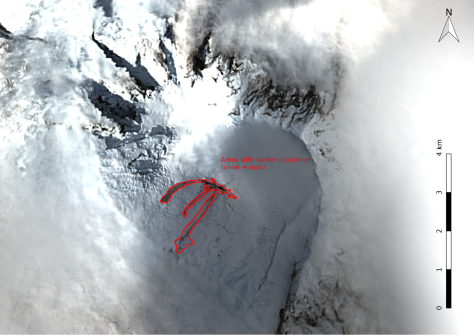
Lava and debris flows radiate away from Mawson Peak on Heard Island.   February 4, 2017.  Image credit: Bill Mitchell (CC-BY) using data from Landsat 8 OLI (NASA/USGS; public domain).
Lava and debris flows radiate away from Mawson Peak on Heard Island. February 4, 2017. Image credit: Bill Mitchell (CC-BY) using data from Landsat 8 OLI (NASA/USGS; public domain).

On February 4th, Landsat 8 captured a clear view of the summit of Big Ben volcano, at Heard Island. Heard Island is a very cloudy location, so clear views are uncommon (I don’t have numbers, but would estimate <20%). However, the February 4th images are even more spectacular: they capture an ongoing volcanic eruption.

Observations
In the sharpened true-color image (above), four or five different lava/rock/debris flows are visible emanating from the summit. Using a false-color infrared image (below), two hot regions are apparent (red/orange/yellow), and are separated by about 250 meters. The longest of the flows stretches nearly 2 km, and drops from an elevation of roughly 2740 m to 1480 m (using 2002 Radarsat elevation data with 20 m contours). All three of the large flows to the west or southwest of the summit drop below 2000 m elevation at the toe.

False-color infrared imagery of Mawson Peak, Heard Island.  Two vents are visible in red/orange/yellow, separated by 250 meters. Data source: Landsat 8 OLI/TIRS bands 7-6-5.  Image credit: Bill Mitchell (CC-BY), data from NASA/USGS (public domain).
False-color infrared imagery of Mawson Peak, Heard Island. Two vents are visible in red/orange/yellow, separated by 250 meters. Data source: Landsat 8 OLI/TIRS bands 7-6-5. Image credit: Bill Mitchell (CC-BY), data from NASA/USGS (public domain).

Interpretation
In the sharpened true-color imagery, I have identified five rock and debris flows originating at the summit, as well as one potential avalanche. Annotation of these observations is found on the pictures below.

Annotation of lava/rock/debris flows from Mawson Peak, Heard Island, February 4, 2017.  Image credit: Bill Mitchell (CC-BY).
Annotation of lava/rock/debris flows from Mawson Peak, Heard Island, February 4, 2017. Image credit: Bill Mitchell (CC-BY).

The streaky, varying lightness of the flow areas, presence of snow and ice, and steep terrain lead me to believe that what is showing up here are mixed snow/rock/lava debris flows, rather than pure lava flows. A mix of rocky debris and snow would not be out of line for a supraglacial eruption on a steep mountain. The longest flow drops nearly 1300 m along its 2000 m horizontal path according to the 2002 Radarsat elevations. I’ll be the first to admit that I am distrustful of the specifics of the Radarsat contours due to the rapidly changing landscape and an intervening 15 years, but I think that it manges to get the general picture right.

Southwestern Heard Island is a high-precipitation area, so rocks exposed on the surface of the glaciers are likely quite fresh. It probably won’t be long before most of the deposits are covered in snow again.

Speaking of snow, it looks as though there is a faint outline of an avalanche scarp/deposit on the northeast side of the summit, which I annotated below in green.

Annotation of avalanche scarp and deposit, Mawson Peak, Heard Island, February 4, 2017.  Image credit: Bill Mitchell (CC-BY)
Annotation of avalanche scarp and deposit, Mawson Peak, Heard Island, February 4, 2017. Image credit: Bill Mitchell (CC-BY)

The two hot spots provide an interesting challenge for interpretation. Two scenarios come to mind quickly: there are two vents from which lava is issuing, or there is a lava tunnel from a summit crater down to a flow front or breakout. Analyzing the Landsat 8 OLI/TIRS infrared imagery from January 26th (most recent previous high-resolution image), only one hot spot is present—in the same place as the eastern hot spot in the February 4th infrared image. For spatial correlation without doing the whole image processing and GIS thing, use the forked flow to the south-southeast of the hotspot as a reference.

False-color infrared image of Mawson Peak, January 26, 2017.  Landsat 8 OLI/TIRS bands 7-6-5.  Image credit: Bill Mitchell (CC-BY) using NASA/USGS data (public domain).
False-color infrared image of Mawson Peak, January 26, 2017. Landsat 8 OLI/TIRS bands 7-6-5. Image credit: Bill Mitchell (CC-BY) using NASA/USGS data (public domain).

Due to a different time of day for imaging, there are significant shadows in the January image on the southwest side of ridges. It’s tricky to figure out what is going on for the flows (even in visible imagery), but the hot spot from January 26th is right on top of the eastern hot spot from February 4th.

Another thing which becomes apparent in the January image is the topography at the summit. The clouds form a blanket at an atmospheric boundary (and roughly-constant elevation), which is conveniently just below the elevation of the summit. A roughly circular hole in the clouds is present, and a conical mountain summit pokes through with the hot spot right in the center. That suggests that the second hot spot seen in the February 4th image is at a lower elevation—a possible flow front or breakout.

Excitement in the Mundane
Finding this eruption was a bit of a surprise to me: the low-resolution preview image for the Landsat data on EarthExplorer was so coarse that there wasn’t anything striking or out of the ordinary visible at the summit. Clouds covered most of the rest of the island. However, when I opened up the full-resolution color images (30 m/pixel), it was immediately evident that this was a special day. Sharpening the true-color bands with the high-resolution panchromatic band using QGIS made it pop all the more!

Upon seeing both the lava/debris flows and the thermal anomaly, I checked the MODIS volcanism (MODVOLC) site to see if the Terra and Aqua MODIS instruments had picked up thermal anomalies as well over the preceding week. They had, as shown below. Both satellites had recorded thermal anomalies at Heard on February 2nd and 3rd.

MODIS thermal events at Heard Island, in the week preceding February 6, 2017.  Image credit: MODVOLC.
MODIS thermal events at Heard Island, in the week preceding February 6, 2017. Image credit: MODVOLC.

Update:: Follow-up from February 27, 2017.

Heard Island’s Most Spectacular Outcrop

Head-on view of a block of Drygalski Formation (mixed volcanics and glacial sediments, here glacial sediments with volcanic clasts).  Image credit: Bill Mitchell (CC-BY).
Head-on view of a block of Drygalski Formation (mixed volcanics and glacial sediments, here glacial sediments with volcanic clasts). 53° 01.927′ S, 73° 23.704′ E. Image credit: Bill Mitchell (CC-BY).

Heard Island is home to a spectacular outcrop. It’s the coolest outcrop I’ve ever seen, besting the Bishop Tuff tablelands, the potholes along the St. Croix River at Taylor’s Falls, Zion Canyon, The Badlands, and various outcrops in Yellowstone and Grand Teton. Admittedly this outcrop doesn’t intrinsically have the scale of many of the others just mentioned—it’s a roughly car-sized block—but the power that went into creating it and the effect it created is truly amazing.

On its face (see above), it looks quite pedestrian: a block of lithified glacial till with clasts of vesicular basalt reaching up to grapefruit size. However, it’s important to consider it from a different perspective.

Side view of a block of Drygalski Formation.  From this view, it is much easier to see this is a ventifact (carved by the wind).  There is a pile of sand on leeward (left) side. Image credit: Bill Mitchell (CC-BY).
Side view of a block of Drygalski Formation. From this view, it is much easier to see this is a ventifact (carved by the wind). There is a pile of sand on leeward (left) side.
Image credit: Bill Mitchell (CC-BY).

When viewed from the side, a pile of sand in on the leeward (left, east) side of the block is evident. Additionally, the basaltic clasts of the rock face seem to be protecting the softer, tan-colored glacial matrix from the sand-blasting.

Here’s a close-up from an oblique angle:

Close-up, oblique view of the outcrop face.  Here the differential weathering (resistant grey clasts, weak tan matrix) is very apparent.  Spires of matrix are left to the leeward of the clasts, and are roughly horizontal. Image credit: Bill Mitchell (CC-BY).
Close-up, oblique view of the outcrop face. Here the differential weathering (resistant grey clasts, weak tan matrix) is very apparent. Spires of matrix are left to the leeward of the clasts, and are roughly horizontal.
Image credit: Bill Mitchell (CC-BY).

In the oblique view, the volcanic clasts making up the face of the outcrop are seen sheltering the matrix directly to the leeward from mechanical erosion. To tie all of these views together, I took a short video (embedded below).

This outcrop is located on the edge of a volcanic sand plain roughly 1.5×1.5 km. Strong westerly winds are present most of the time (9 m/s is average, measured at a site nearby).[1] In fact, the audio which accompanies the video is mostly wind noise, though there’s a little unintelligible chatter with my field partner, Carlos. Winds when the recording was made were “moderate” (for Heard Island) and from the west, exactly the kind of winds that shaped this outcrop. At the time of the recording, the winds weren’t strong enough to kick up much sand, nor were ice pellets falling from the sky, but on a gustier, stormier day, the face of this outcrop will take a beating.

Looking toward the ventifact outcrop from Windy City, Heard Island.  Although the outcrop itself is hidden behind the small reddish rise at center, this image illustrates the expanse of vegetation-free sand plain. Image credit: Bill Mitchell (CC-BY).
Looking toward the ventifact outcrop from Windy City, Heard Island. Although the outcrop itself is hidden behind the small reddish rise at center, this image illustrates the expanse of vegetation-free sand plain.
Image credit: Bill Mitchell (CC-BY).

In my travels and geo-adventures, I’ve seen differential weathering and ventifacts (outcrops shaped by wind), but never so strikingly combined as at this outcrop on Heard Island. That’s why I can confidently say it’s the coolest outcrop I’ve seen on Heard Island or anywhere else in the world.

[1] Thost, D., Allison, I. “The climate of Heard Island” in Heard Island: Southern Ocean Sentinel, ed by K. Green and E. Woehler. Surrey Beatty & Sons, Chipping Norton 2005, p. 52-68.

The Making of the Windy City Gigapan

Looking eastward at Windy City, with a person for scale. The gigapanned portion of the outcrop is at right, but two spires of similarly eroded rock outcrop further to the north of the photographed portion. The stake coming out from the outcrop is a marker for one of our temperature/light intensity sensors. Image credit: Carlos Nascimento
Looking eastward at Windy City, with a person for scale. The gigapanned portion of the outcrop is at right, but two spires of similarly eroded rock outcrop further to the north of the photographed portion. The stake coming out from the outcrop is a marker for one of our temperature/light intensity sensors.
Image credit: Carlos Nascimento

In my previous post, I discussed the gigapan of Windy City. However, the making of that gigapan was quite the adventure in field work.

After the Azorella Peninsula gigapan, the unit was packed up and taken back aboard the Braveheart for a trip to the southeast portion of the island. Rough north winds were expected, and with no protection afforded against those winds and swells from Atlas Cove, the ship had to move. Our expedition leader and two scientists not involved in the radio operations left camp and went to ride out the storm south of Stephenson Lagoon. At that time, it had become clear that I personally would not be able to go to Stephenson Lagoon—an area which was an extremely high priority for a gigapan image. I put fresh batteries into the gigapan mount, and sent it on its way. Sadly, in the almost four hours the team had on the shores of Stephenson Lagoon, they did not have an opportunity to take a gigapan. I’ll have to go back for that one!

Upon their return to camp, I knew since they had not attempted any gigapanning that there were fresh batteries in the unit. As the end of the expedition drew near, it was time to get the gigapan done at Windy City. Mid-morning, Carlos joined me for a trip to the outcrop (about 1.4 km each way). Although we didn’t have a bright sunny day, it was dry with a temperature around 5 °C. When we reached the outcrop and everything was set up, I turned on the gigapan mount. Nothing happened. With new batteries and a limited task, I hadn’t brought the whole kit with me. We headed back to camp, arriving in time for lunch.

Several of the rechargeable batteries I had for the gigapan had been sitting on the charger and were ready to go. I tossed those into the battery holder, put it under my arm to keep warm, and headed out with Carlos once again. At the outcrop I set up the rig again. When everything was set to go, I removed the batteries from inside my jacket, and put them into their slot. I powered it on. The LCD display brightened, but displayed an error message: Button-pusher disconnected or plugged in backwards. Cycling the power on and off didn’t fix it. Everything was as it had been before when it worked. Once again, this was a problem I was unable to deal with at the outcrop.

Back in camp, Carlos looked online for a solution while I tried to see if anything was likely to have come disconnected, although our team had been very gentle with the unit. Nothing stood out. Eventually we found online that the error is commonly caused not by a disconnected or backwards button-pusher, but by a low voltage. That made a bit more sense. Out came the volt-meter, and two sets of six AA alkaline batteries were verified to be fresh. One set went into the battery holder, the other went into a storage case. Now that it was late in the afternoon, Carlos had to report for radio duty, but Adam was willing to come with me—I needed this gigapan before the light died, as there was no guarantee that I would have the weather conditions or time to get it later.

Adam and I hurried over to the outcrop, the light already beginning to fade. I set up quickly, got the batteries out from my jacket, and set up the gigapan.

Please, light, stay with us long enough to complete this shot. Please, batteries, keep up your voltage!

It was clear from the beginning that the shot would not be truly completed. Somewhere in the middle either the light would die or the batteries would. Eventually, both did at about the same time. We quickly put everything back into the packs and headed back for camp. It was getting dark, but we arrived just in time for dinner and the start of my shift at the radio desk.

Although it was too late to be of use, I asked on Twitter what some of the other cold-weather folks had done about their gigapans. By the end of my four-hour radio shift, I had responses from @rschott and @callanbentley. Evidently this is a common problem, which is fought by insulating the gigapan unit as well as possible, and using hand/toe-warmers to add a little heat.

I think it’s time to ask Gigapan to make some design adjustments to improve the cold-weather operation of the units. It wasn’t all that cold where I was gigapanning, yet I still couldn’t get 15 minutes of operation on fresh batteries at 3–5 °C.

Windy City Gigapan

Processing the Windy City gigapan.  Image credit: Bill Mitchell (CC-BY).
Processing the Windy City gigapan. Image credit: Bill Mitchell (CC-BY).

This is the third in a series of three posts about the gigapan images taken on Heard Island (1: Big Ben, 2: Azorella Peninsula), with more information about the Windy City gigapan.

Windy City is located about 200 meters south of Atlas Cove, in the northwest portion of Heard Island. It comes from a fin of Drygalski Formation rocks, which are a mix of glacial sediments and volcanics, and is mostly surrounded by sand and gravel plains.

Looking closely at the outcrop, there are a number of interesting things to observe. First, there are the striking roughly-horizontal marks, which are particularly evident toward the base of the outcrop. Second, the outcrop is made of massive, fine-grained jointed rocks with few vesicles. Third, there are quite a few fractures within the rock, with discolorations along many of the cracks.

All of these observations combine into a remarkable tale of how Windy City has been formed. The massive, fine-grained, and jointed appearance leads to the conclusion that we are looking at a volcanic outcrop, rather than glacial sediments. Fracturing and discoloration have been brought on by weathering from the very wet, near-freezing environment. Finally, the wind has been a huge factor! Sand, gravel, snow, and graupel (ice pellets) have all been blasted against the side of this outcrop, primarily from the west (at right). On Heard Island, a 9 m/s wind is typical, with maximum recorded gusts exceeding 50 m/s on three days during the 1948-1954 period.[1] The high winds sandblast the outcrop, leading to the horizontal striations.

Here are a few wider-angle shots for context, and with better light than I ended up with for the gigapan.

Windy City outcrop, viewed from the north.  The gigapan image covers from my right arm to roughly the center of this image.  Image credit: Carlos Nascimento
Windy City outcrop, viewed from the north. The gigapan image covers from my right arm to roughly the center of this image. Image credit: Carlos Nascimento

Looking eastward at Windy City, with a person for scale.  The gigapanned portion of the outcrop is at right, but two spires of similarly eroded rock outcrop further to the north of the photographed portion.  The stake coming out from the outcrop is a marker for one of our temperature/light intensity sensors. Image credit: Carlos Nascimento
Looking eastward at Windy City, with a person for scale. The gigapanned portion of the outcrop is at right, but two spires of similarly eroded rock outcrop further to the north of the photographed portion. The stake coming out from the outcrop is a marker for one of our temperature/light intensity sensors.
Image credit: Carlos Nascimento

I also managed a close-up shot of one of the pieces of float.

Float rock at Windy City.  The 1:1000 metric scale at right is effectively a mm scale.  Some olive/green crystals are visible, mostly 1-5 mm in their longest dimension, which are likely olivine (possibly clinopyroxene). Image credit: Bill Mitchell (CC-BY).
Float rock at Windy City. The 1:1000 metric scale at right is effectively a mm scale. Some olive/green crystals are visible, mostly 1-5 mm in their longest dimension, which are likely olivine (possibly clinopyroxene).
Image credit: Bill Mitchell (CC-BY).

[1] Thost, D., Allison, I. “The climate of Heard Island” in Heard Island: Southern Ocean Sentinel, ed by K. Green and E. Woehler. Surrey Beatty & Sons, Chipping Norton 2005, p. 52-68.

Azorella Peninsula Gigapan

Processing the Azorella Peninsula gigapan.  Image credit: Bill Mitchell (CC-BY).
Processing the Azorella Peninsula gigapan. Image credit: Bill Mitchell (CC-BY).

This is the second in a series of three posts about the gigapan images taken on Heard Island (1: Big Ben, 3: Windy City), with more information about the Azorella Peninsula gigapan.

The Azorella Peninsula is on the northern edge of the main part of Heard Island, east of the Laurens Peninsula. It forms the eastern boundary of Atlas Cove (Laurens Peninsula forms the western boundary; see map below). At the west end of the Azorella Peninsula’s southern margin is the heritage zone around the ANARE campsite, two water-tank shelters, a green “apple” shelter, and the area where our expedition made camp. That many of the camps are all in the same area is no accident: Atlas Cove is probably the best harbor on the island (though still not sheltered from a northerly swell), there is a convenient beach for boat landings, and a small step up of elevation from the lava flows of the Azorella Peninsula provides higher ground than the sometimes-inundated Nullarbor.

Heard Island Map, 1985. Image credit: excerpt from the Division of National Mapping.

Getting a gigapan here was not as straightforward as I had hoped. Although there were plenty of pahoehoe flow tops, cracks where a flow had deflated and collapsed in on itself, and other lava flow features, few of them were of a scale and in a location which enabled them to be nicely gigapanned with the tripod I had. With another 3–5 m of elevation, the gigapan would be spectacular.

As it was, there were some additional features besides the lava flows which I wanted to include. For one, the landscape has significant erosional processes happening, and there are sandy areas which get washed when it rains. Even more than the rain, though, the wind creates eolian features. Many of the small rocks have a little dune in their lee, and often the Kerguelen cabbage and Azorella moss grow on the leeward side of rock barriers as well. Some of this organization is visible in the gigapan.

At the top right of the Gigapan image, and lost to the fog and overexposure of the image, is a strongly layered prominence: Corinth Head. Although I would have liked to go see this outcrop up close, our permit did not allow that—the area is a major nesting site for burrowing seabirds, and in places there are lava tubes with thin ceilings which may give way underfoot.

Corinth Head, Heard Island, viewed from the south (further east than the Gigapan was taken).  Layering is clearly visible, and is likely of igneous origin.  Image credit: Bill Mitchell (CC-BY).
Corinth Head, Heard Island, viewed from the south (further east than the Gigapan was taken). Layering is clearly visible, and is likely of igneous origin. Image credit: Bill Mitchell (CC-BY).

Where the Azorella Peninsula lava flow field meets the Nullarbor, there was a little flow which caught my eye. There, one flow clearly traveled through an older channel or tube. Weathering has removed some of the older flow, giving a cross-sectional view of the dark vesicular rock.

Lava flows of the Azorella Peninsula meet the Nullarbor.  An older, grey unit is visible with a redder unit in the middle.  Notebook is 19 cm wide.  Image credit: Bill Mitchell (CC-BY).
Lava flows of the Azorella Peninsula meet the Nullarbor. An older, grey unit is visible with a redder unit in the middle. Notebook is 19 cm wide. Image credit: Bill Mitchell (CC-BY).

Some lava tubes showed obvious signs of deflation or lava tube collapse. The one seen below had eolian features nearby, and the Kerguelen cabbage and Azorella moss can be seen growing on the leeward side of the rocks. An elephant seal is also present.

Deflated lava flow beside the Nullarbor on the Azorella Peninsula, Heard Island.  Some eolian features are present.  Note the Azorella moss and Kerguelen cabbage at right, in the lee of the solid rocks.  The tan mass at right is an elephant seal.  Notebook is 12x19 cm.  Image credit: Bill Mitchell (CC-BY).
Deflated lava flow beside the Nullarbor on the Azorella Peninsula, Heard Island. Some eolian features are present. Note the Azorella moss and Kerguelen cabbage at right, in the lee of the solid rocks. The tan mass at right is an elephant seal. Notebook is 12×19 cm. Image credit: Bill Mitchell (CC-BY).

Finally, here is another example of a collapsed lava tube, which shows off a cross-section of the top of the lava tube as well as some pahoehoe flow tops.

A collapsed lava tube on the Azorella Peninsula, Heard Island, gives a cross-sectional view of the roof of the lava tube.  Kerguelen cabbage plants in foreground are roughly 25 cm across.  Several pahoehoe flow tops are visible: small-scale in the foreground, and large-scale in the center toward the top of the image.  Image credit: Bill Mitchell (CC-BY).
A collapsed lava tube on the Azorella Peninsula, Heard Island, gives a cross-sectional view of the roof of the lava tube. Kerguelen cabbage plants in foreground are roughly 25 cm across. Several pahoehoe flow tops are visible: small-scale in the foreground, and large-scale in the center toward the top of the image. Image credit: Bill Mitchell (CC-BY).

Big Ben Gigapan

Processing the Big Ben gigapan.  Screenshot by Bill Mitchell.
Processing the Big Ben gigapan. Screenshot by Bill Mitchell.

This post is the first in a series of three on the gigapans I took on Heard Island. (Part 2, Part 3)

My first gigapan on Heard Island, this one of Big Ben, came unexpectedly. As I was out hiking one afternoon, my hiking partner, Arliss, noticed that we had a clear view of the summit of Big Ben. Clearings like this can be relatively short and infrequent, so we took a few pictures immediately. We headed back to base camp just east of Atlas Cove, arriving under an hour before sunset. The mountain was still visible, so I moved quickly to set everything up and get the gigapan taken before the light faded.

From camp, Big Ben is situated to the southeast, rising up beyond the flat sandy plain of the nullarbor. In this view, the moraines and glaciers begin about 2 km from the camera. To the right of the image is the eastern slope of Mt. Drygalski. The edge of the Azorella Peninsula lava flow is in the bottom left corner.

Glacial features dominate the landscape, including a prominent moraine now covered in vegetation (lower right). Coming toward the camera are the Schmidt and Baudissin glaciers. I think this view covers from the Allison and Vahsel glaciers (at right) to the Ealey glacier (at left).

On the Nullarbor, there are a few king penguins and elephant seals, primarily to the left of center.

Big Ben itself has a range of rock types, including basanites, alkali basalts, and trachybasalts, overlying limestones and volcanic/glacial deposits.[1-4]

[1] Quilty, P. G.; Wheller, G. (2000) Heard Island and The McDonald Islands: a Window into the Kerguelen Plateau. Papers and Proceedings of the Royal Society of Tasmania. 133 (2), 1–12.

[2] Barling, J.; Goldstein, S. L. (1990) Extreme isotopic variations in Heard Island lavas and the nature of mantle reservoirs. Nature 348:59–62, doi 10.1038/348059a0.

[3] Barling, J.; Goldstein, S. L.; Nicholls, I. A. (1994) Geochemistry of Heard Island (Southern Indian Ocean): Characterization of an Enriched Mantle Component and Implications for Enrichment of the Sub-Indian Ocean Mantle. Journal of Petrology 35:1017–1053, doi 10.1093/petrology/35.4.1017.

[4] Stephenson, J.; Barling, J.; Wheller, G.; Clarke, I. “The geology and volcanic geomorphology of Heard Island”, in Heard Island: Southern Ocean Sentinel (Eds K. Green and E. Woehler) Surrey Beatey & Sons, 2006, p. 10–27.

Farewell, Cape Town!

HDT Airbeam tent being loaded onto the Braveheart.  The tent is also blocking a nice view of Table Mountain.  Image credit: VK0EK team.

We are in the final breakfast and boarding process for departing Cape Town. Above is a picture from yesterday, where all the inspected expedition gear was loaded onto the Braveheart.

Cape Town has been very nice. Our hotel is within an easy walk of the ship, and there are many shops nearby where we have acquired food, groceries, clothing, outdoor gear, and souvenirs. Weather has been quite warm (26 °C, 79 °F) with a breeze. The local Cape Town team has been extremely helpful and have made much of the project move more smoothly. Crew from the Braveheart have also been wonderful to work with, and I’m looking forward to getting to know them more in the next six weeks. As the ships were loading, a seal was playing in the harbor, gulls were flying around, and even a few terns were spotted.

As can be seen in the photo above, there is some interesting geology around Cape Town. Most noticeable is Table Mountain, which is primarily made up of the Table Mountain Sandstone. Closer to the hotel is Signal Hill, which has slates that have been tilted nearly vertical. We were able to see these up close yesterday evening after the ship was loaded and things were under control. It’s quite a view from up there (sorry, haven’t had time to process pics). For more on the geology of Cape Town, take a look at this post by Dr. Evelyn Mervine, who writes one of the AGU blogs.

Internet connectivity on the ship is likely to be minimal, but with luck I’ll be able to get a post or two up from Heard Island! More frequent news updates can be found at vk0ek.org.