Tag Archives: geomorphology

Kicking Wax and Taking Frames

Cross-country ski tracks along the shore of a lake.

Yesterday, a big snowstorm dumped about 30 cm (12″) of snow on Minneapolis, and high winds blew that snow around. On my way home from lab, the train worked well, but I definitely chose correctly when I decided to walk home from the train (2-3 km) rather than take the bus. The roads were a mess, but walking wasn’t too bad.

When that much snow falls that quickly, skiing can be much better for getting around than driving. After dinner I hopped on the skis to go tour around the neighborhood and enjoy being on snow for the first time this winter. I’d barely skied half a block when a car got stuck turning and I helped get them through the intersection.

Skiing around the lake was wonderful. There’s something magical about the quiet of lots of new-fallen snow, and even though the skiing was slow-going, it was fun. However, with it being dark and my being on skis for the first time this winter, I didn’t bring a camera with me.

This morning I went out again and took the camera, because there was a lot of neat stuff to be seen. After helping two more cars get unstuck, I made it to the lake. There were tracks: skis (see photo above), boots, snowshoes, and dogs, plus tire tracks in the roads. High winds had also led to drifting, so there were eolian features as well: mini-dunes, scoops, and even some parabolic or blowout features.

Park bench with snow scoop.

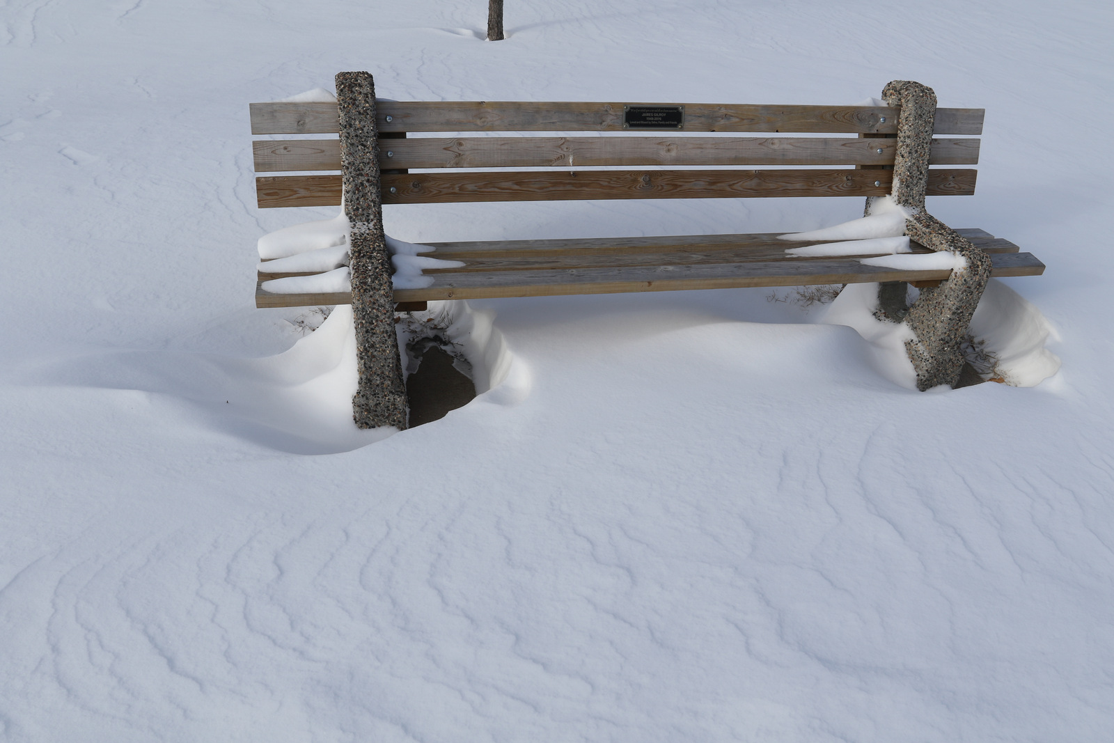
Scoops form when wind has to travel around an object such as a tree, rock, or the legs of a park bench. Because the wind velocity increases on the leading edge of the feature, snow or sand get removed from in front of the obstruction.

Minneapolis on a sunny, snow-covered day.

The lake is a great place to look for eolian features, because its flat surface without plants or other obstructions provides a large windy area. Miniature dunes formed, with steep faces to windward, and shallower slopes on the leeward side. In the photo of the lake above, the wind was traveling left-to-right. It also features a pair of cross-country ski tracks!

Blowout feature on the leeward side of a lake.

One of the neat features was this blowout on the south (leeward) side of the lake. Last night it seemed to be a fairly parabolic feature, but today it was clearly a blowout. The grasses slowed the wind and provided a place for snow to accumulate, while the gap between grass tussocks was a high-wind area. Scouring is evident near the gap, but deposition follows not far downwind, and the parabolic shape of the features is visible.

Blowout feature on the leeward side of a lake.

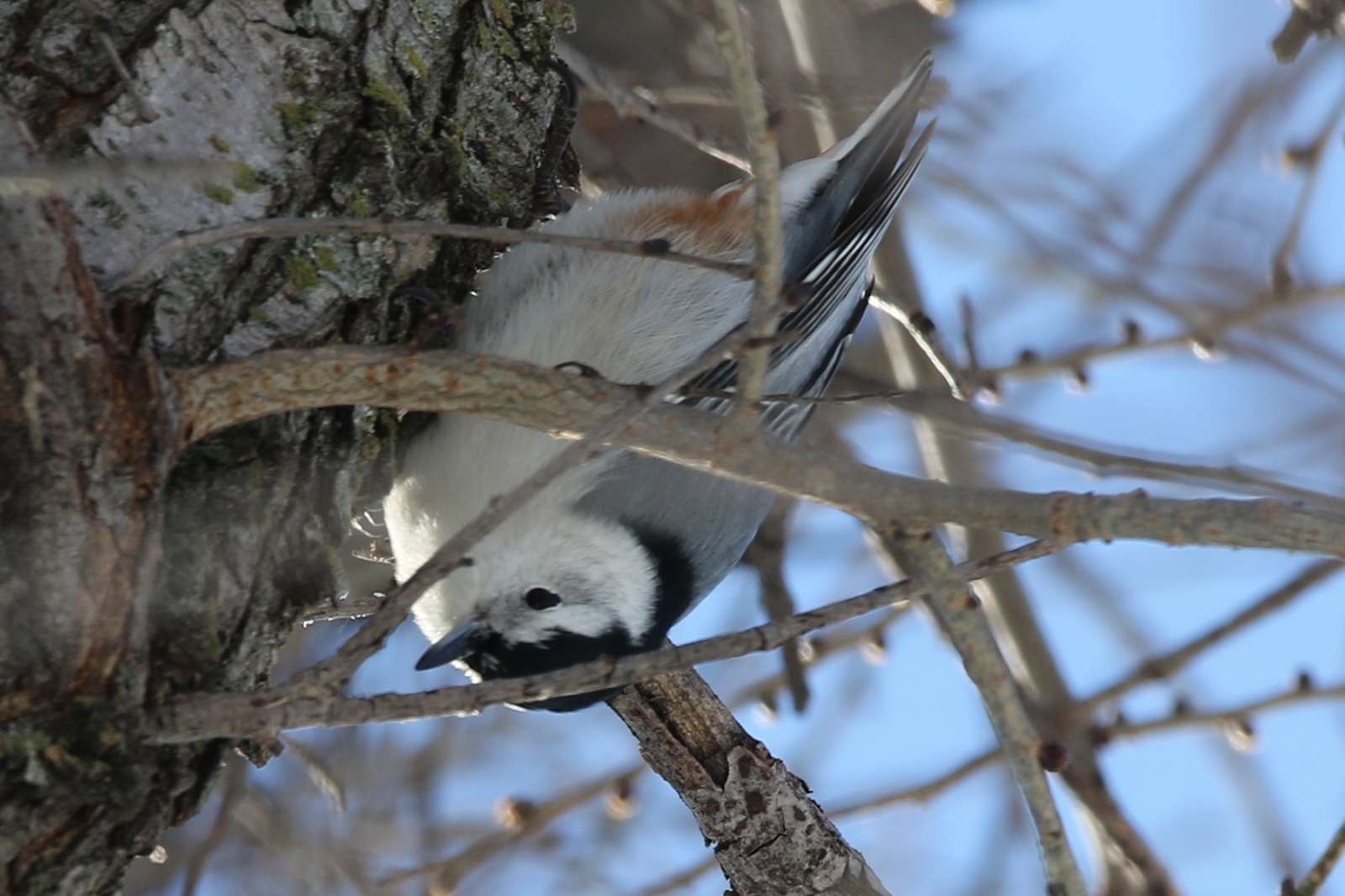
There were a few birds out and about this morning, too! A white-breasted nuthatch was foraging in a tree above me, and several other nuthatches were fluttering around nearby.

White-breasted nuthatch.

It was a fun expedition out skiing, and I was happy to take some pictures along the way. The snowplows were busy while I was out, and several of the streets had been cleared before I got back home, so there were fewer cars to help out of the deep snow.

Azorella Peninsula Gigapan

Processing the Azorella Peninsula gigapan.  Image credit: Bill Mitchell (CC-BY).
Processing the Azorella Peninsula gigapan. Image credit: Bill Mitchell (CC-BY).

This is the second in a series of three posts about the gigapan images taken on Heard Island (1: Big Ben, 3: Windy City), with more information about the Azorella Peninsula gigapan.

The Azorella Peninsula is on the northern edge of the main part of Heard Island, east of the Laurens Peninsula. It forms the eastern boundary of Atlas Cove (Laurens Peninsula forms the western boundary; see map below). At the west end of the Azorella Peninsula’s southern margin is the heritage zone around the ANARE campsite, two water-tank shelters, a green “apple” shelter, and the area where our expedition made camp. That many of the camps are all in the same area is no accident: Atlas Cove is probably the best harbor on the island (though still not sheltered from a northerly swell), there is a convenient beach for boat landings, and a small step up of elevation from the lava flows of the Azorella Peninsula provides higher ground than the sometimes-inundated Nullarbor.

Heard Island Map, 1985. Image credit: excerpt from the Division of National Mapping.

Getting a gigapan here was not as straightforward as I had hoped. Although there were plenty of pahoehoe flow tops, cracks where a flow had deflated and collapsed in on itself, and other lava flow features, few of them were of a scale and in a location which enabled them to be nicely gigapanned with the tripod I had. With another 3–5 m of elevation, the gigapan would be spectacular.

As it was, there were some additional features besides the lava flows which I wanted to include. For one, the landscape has significant erosional processes happening, and there are sandy areas which get washed when it rains. Even more than the rain, though, the wind creates eolian features. Many of the small rocks have a little dune in their lee, and often the Kerguelen cabbage and Azorella moss grow on the leeward side of rock barriers as well. Some of this organization is visible in the gigapan.

At the top right of the Gigapan image, and lost to the fog and overexposure of the image, is a strongly layered prominence: Corinth Head. Although I would have liked to go see this outcrop up close, our permit did not allow that—the area is a major nesting site for burrowing seabirds, and in places there are lava tubes with thin ceilings which may give way underfoot.

Corinth Head, Heard Island, viewed from the south (further east than the Gigapan was taken).  Layering is clearly visible, and is likely of igneous origin.  Image credit: Bill Mitchell (CC-BY).
Corinth Head, Heard Island, viewed from the south (further east than the Gigapan was taken). Layering is clearly visible, and is likely of igneous origin. Image credit: Bill Mitchell (CC-BY).

Where the Azorella Peninsula lava flow field meets the Nullarbor, there was a little flow which caught my eye. There, one flow clearly traveled through an older channel or tube. Weathering has removed some of the older flow, giving a cross-sectional view of the dark vesicular rock.

Lava flows of the Azorella Peninsula meet the Nullarbor.  An older, grey unit is visible with a redder unit in the middle.  Notebook is 19 cm wide.  Image credit: Bill Mitchell (CC-BY).
Lava flows of the Azorella Peninsula meet the Nullarbor. An older, grey unit is visible with a redder unit in the middle. Notebook is 19 cm wide. Image credit: Bill Mitchell (CC-BY).

Some lava tubes showed obvious signs of deflation or lava tube collapse. The one seen below had eolian features nearby, and the Kerguelen cabbage and Azorella moss can be seen growing on the leeward side of the rocks. An elephant seal is also present.

Deflated lava flow beside the Nullarbor on the Azorella Peninsula, Heard Island.  Some eolian features are present.  Note the Azorella moss and Kerguelen cabbage at right, in the lee of the solid rocks.  The tan mass at right is an elephant seal.  Notebook is 12x19 cm.  Image credit: Bill Mitchell (CC-BY).
Deflated lava flow beside the Nullarbor on the Azorella Peninsula, Heard Island. Some eolian features are present. Note the Azorella moss and Kerguelen cabbage at right, in the lee of the solid rocks. The tan mass at right is an elephant seal. Notebook is 12×19 cm. Image credit: Bill Mitchell (CC-BY).

Finally, here is another example of a collapsed lava tube, which shows off a cross-section of the top of the lava tube as well as some pahoehoe flow tops.

A collapsed lava tube on the Azorella Peninsula, Heard Island, gives a cross-sectional view of the roof of the lava tube.  Kerguelen cabbage plants in foreground are roughly 25 cm across.  Several pahoehoe flow tops are visible: small-scale in the foreground, and large-scale in the center toward the top of the image.  Image credit: Bill Mitchell (CC-BY).
A collapsed lava tube on the Azorella Peninsula, Heard Island, gives a cross-sectional view of the roof of the lava tube. Kerguelen cabbage plants in foreground are roughly 25 cm across. Several pahoehoe flow tops are visible: small-scale in the foreground, and large-scale in the center toward the top of the image. Image credit: Bill Mitchell (CC-BY).